Green Line Metro Stations 🚇
Table of Contents
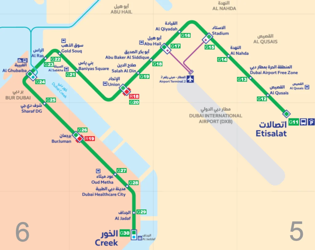
🟢 The Green Line is one of the two lines on the Dubai Metro Map public transport system. It stretches from Etisalat Metro Station in Al Qusais to Creek Metro Station.
🔴 Dubai Metro Red Line Stations: from Centerpoint station to Expo 2020 and UAE Exchange stations.
✨ As the Green Line winds its way through the vibrant and densely populated areas of Deira and Bur Dubai, it provides convenient access to countless landmarks and destinations. 🏙️
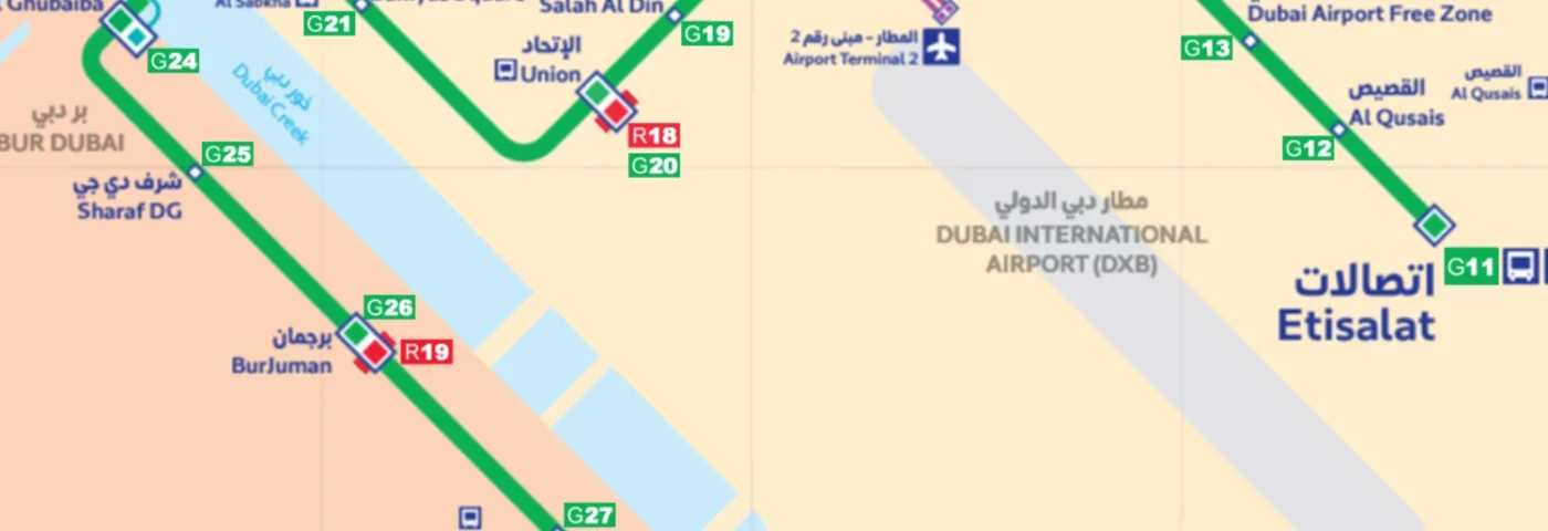
🚉 The Dubai Metro Green Line offers two transfer stations 🔄 for passengers to switch to the Red Line easily: Union and BurJuman (Formerly Khalid Bin Al Waleed). Check out the Dubai Metro Green Line map to see these locations.
🗺️ Additionally, an underground section of 5 miles stretches from Abu Baker Al Siddique to Oud Metha. 🚇
Drivers can park their cars at the park-and-ride facility at Etisalat Metro Station (G11). There are spaces for around 2,300 cars and parking is free for Metro passengers.
👀 Curious to explore the Dubai Metro Green Line? Take a look at the Dubai Metro Green Line Map! 🗺️
So, hop on board the Green Line and enjoy a seamless and captivating journey through the bustling city of Dubai. 🌆
Don’t forget to check out Dubai Bus timings and routes! 🚌
🟩 Green Line Metro Stations Map

🕑 Green Line Metro Timings
Green Line Timings in 2023:
- Monday to Thursday: 5:00 AM to 12:00 AM
- Friday: 5:00 AM to 1:00 AM
- Saturday: 5:00 AM to 12:00 AM
- Sunday: 8:00 AM to 12:00 AM
Remember that the first and last train times vary for each station, and metro operating hours can also change during public holidays.
Green Line trains frequency:
- Every four minutes during peak hours.
- Every seven minutes at off-peak times.
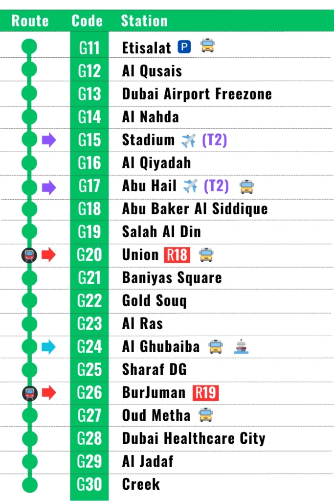
📍 Green Line Metro Stations List
🔄 Transfer Stations:
The Green Line 🟢 has two transfer stations with the Red Line 🔴 at Union and BurJuman stations.
Abu Hail and Stadium stations provide interchanges with Dubai Airport Terminal 2 ✈️
Al Ghubaiba metro station allows transfers to the Al Ghubaiba Marine Transport Station, serving routes to Sharjah Aquarium and Dubai Canal ⛴️

🗺️ Green Line Metro Stations Guide
The Green Line features a 22.5-kilometer-long track. It takes you from the Al Qusais area Etisalat station, passing through the vibrant Dubai Creek (Deira and Bur Dubai), and ends at the last station called Creek. Along its route, you’ll find a total of 20 stations, with 12 elevated and 8 underground.
| English Name | Arabic Name | Zone | Metro Feeder | Bus Station |
|---|---|---|---|---|
| Etisalat | e& اتصالات من | 5 | F02, F07 | Yes |
| Al Qusais | اﻟﻘﺼﻴﺺ | 5 | ||
| Dubai Airport Freezone | المنطقة الحرة مطار دبي | 5 | ||
| Al Nahda | النهدة | 5 | F21 | |
| Stadium | الاستاد | 5 | ||
| Al Qiyadah | القيادة | 5 | ||
| Abu Hail | أبو هيل | 5 | Yes | |
| Abu Baker Al Siddique | أبو بكر الصديق | 5 | ||
| Salah Al Din | صلاح الدين | 5 | ||
| Union | الاتحاد | 5 | F01 | Yes |
| Baniyas Square | بني ياس | 5 | ||
| Gold Souq | سوق الذهب | 5 | Yes | |
| Al Ras | الراس | 5 | ||
| Al Ghubaiba | الغبيبة | 6 | Yes | |
| Sharaf DG | شرف دي جي | 6 | ||
| BurJuman | برجمان | 6 | ||
| Oud Metha | عود ميثاء | 6 | F18 | Yes |
| Dubai Healthcare City | مدينة دبي الصحية | 6 | ||
| Al Jadaf | الجداف | 6 | ||
| Creek | الخور | 6 |
🎢 Attractions near Green Line Stations
| Station | Attraction |
|---|---|
| Etisalat | Al Twar Park |
| Al Qusais | Al Qusais Pond Park |
| Dubai Airport Freezone | Dubai Airport |
| Al Nahda | Al Bustan Centre |
| Stadium | Rashid Stadium, Lulu Hypermarket, Al Mulla Plaza |
| Al Qiyadah | Dubai Police HQ |
| Abu Hail | Abu Hail Centre |
| Abu Baker Al Siddique | Hamarain Centre, Al Muteena Park |
| Salah Al Din | Al Ghurair Centre, Reef Mall |
| Union | Al Ghurair Centre, Union Square, Dubai Creek, Twin Towers |
| Baniyas Square | Naif Souk, Al Manal Centre |
| Gold Souq | Gold Souk |
| Al Ras | Sheikh Saeed Al Maktoum House |
| Al Ghubaiba | City Centre Al Shindagha |
| Sharaf DG | Dubai Museum, Old Souk, Al Seef |
| BurJuman | BurJuman, Karama |
| Oud Metha | Rashid Hospital, St Mary Catholic Church, Creek Park |
| Dubai Healthcare City | Wafi City, Wafi Mall, Khan Murjan, Dubai Dolphinarium |
| Al Jadaf | Jaddaf Waterfront |
| Creek | Mohammed bin Rashid Library, Al Jaddaf Marine Transport Station |
🚉 Green Line Metro Stations Features
- Escalators and lifts 🛗
- Washroom facilities, including accessible options ♿️
- Contrasting tactile guidance paths for the visually impaired 🚶♂️🚶♀️
- Information displayed on screens 📺
- Food outlets, ATMs, and vending machines for newspapers and NOL cards 🍔💰📰💳
- Pick-up and drop-off areas 🚕👥
- Bus connections, taxi ranks, and bicycle locking systems 🚌🚖🚲
- 🗺️ Planning your metro trip is a breeze with the user-friendly RTA online journey planner. 📲
🚇 Green Line Trains Features
📌 Fully automated driverless operation.
🌬️ All the trains and stations are air-conditioned and clean.
📶 Free Wi-Fi access.
📱 Mobile phone coverage throughout the entire metro network, including trains and stations.
🚪 Automated Platform Screen Doors – the doors are synchronized and remain open for around 20 seconds.
📺 Information is displayed on screens in every station and train.
🎥 Cameras on trains and stations ensure safety.
🚆 Metro Trains:
- Each metro train has 5 cabins, one of which is separated into two halves.
- Gold class section offers leather seats, carpet flooring, and extra leg space.
- Dedicated compartment exclusively for women and children, with additional space for strollers.
- Other 4 cabins are standard.
- Designated spaces for passengers with physical disabilities.
👍 Enjoy a convenient, safe, and comfortable journey with Dubai Metro Green Line! 👍
👉 FAQ
🚆 How can I pay for tickets on the Dubai metro?
💳 You can use your NOL card balance to pay for your metro tickets. You can purchase a NOL card in most metro stations and charge it with your credit card.
🔄 How to change Metro to Tram or Monorail?
🟢 The Green Line’s main departure is at Al Qusais area’s Etisalat station 🚂 where the trains’ maintenance work, washing, and cleaning are done. Various connection options are available within the metro lines. From the metro, you can transfer to another metro line 🚉 or the tram 🚊. You can also choose between a bus 🚌 and a taxi 🚖. Car parks are also available if you prefer to use your car or wish to travel further by metro 🅿️.
🚉 Metro to Metro:
👉 There are 2 stations for transferring from one metro line to another: at Union 🚉 and BurJuman 🚉 station. Everything is shown in the Dubai metro green line map 🗺️.
🚉 Metro to Tram:
🚊 The Dubai Tram operates at the Dubai Marina and Jumeirah district. You can get to the tram at 2 stations of the Red Line metro: at Jumeirah Lake Towers 🚉 and Dubai Marina 🚉 stations. Check Dubai Tram Map.
🚉 Metro to Monorail:
🚝 Even though there is no direct connection between the metro and the monorail, the monorail is easily accessible 🏞️ because of the Dubai Tram. The Red Line metro links to the tram at two stations: Jumeirah Lake Towers 🚉 and Dubai Marina (new name: DAMAC) 🚉 station. You can continue your trip to the monorail by transferring it via a footbridge at Palm Jumeirah tram station (Gateway monorail station).
