Red Line Metro Stations 🚇
Table of Contents
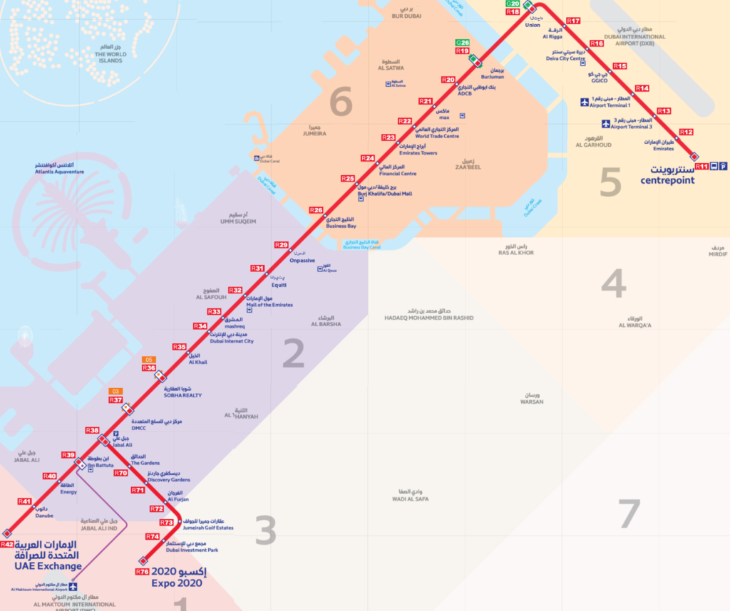
🚇 Discover the Dubai Red Line Metro! An integral part of the Dubai Metro Map network, this impressive line spans 52.1 km and comprises 29 stations. 🌆 It connects Centerpoint in the east to UAE Exchange (Jebel Ali) to the west, predominantly following the iconic Sheikh Zayed Road. 🛣️
🟥 The Red Line runs parallel to Sheikh Zayed Road for most of its length, making it easily accessible from various parts of Dubai. 🌍
⏱️ The entire journey time on the Red Line is approximately 74 minutes, with trains traveling at a maximum speed of 110 km/h (68 mph). 🚄 Each station has a short 20–30 seconds stopping time. The average time between stations ranges from 60–90 seconds. ⌛️
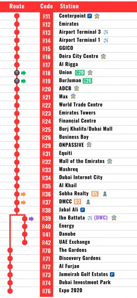
🅿️ For commuters driving to the Red Line, parking options are available at Centerpoint Metro Station (R11), Jebel Ali Metro Station (R38), and Jumeirah Golf Estates Metro Station (R73). 🚘
🌟 Experience the world’s longest single metro line to use driverless trains, as recognized by Guinness World Records in 2011. Get ready to embark on an effortless and convenient journey with the Dubai Red Line Metro! 🚇
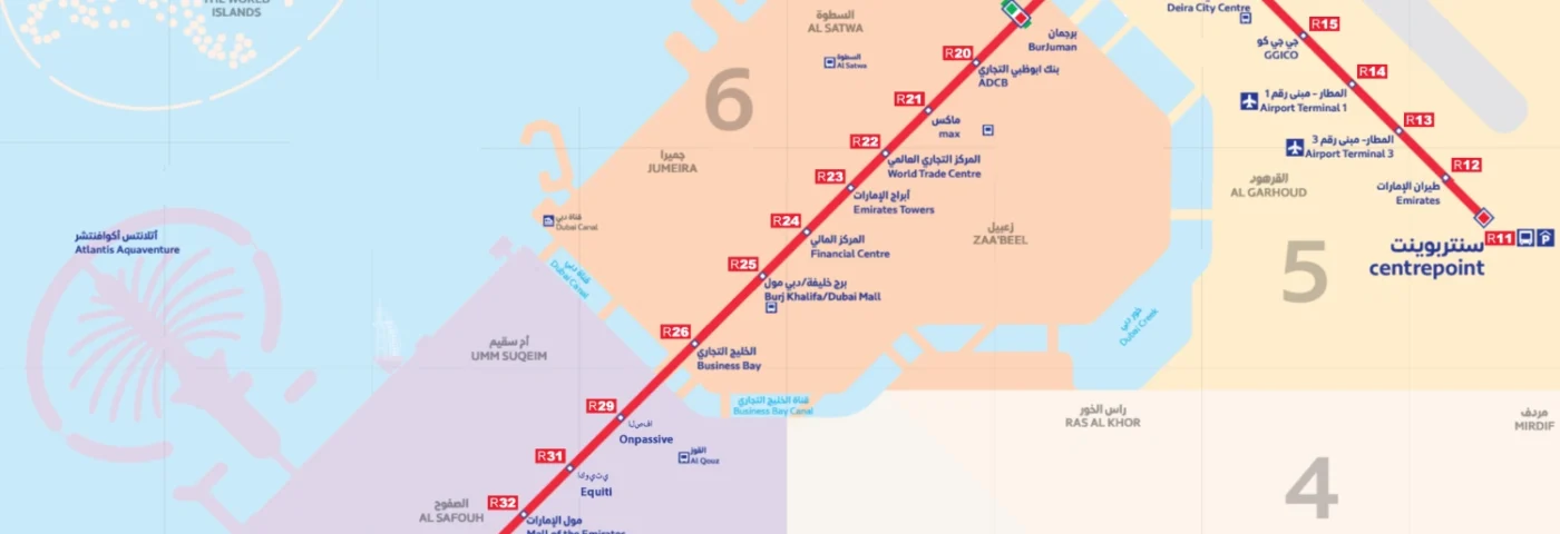
🟥 Red Line Metro Stations Map

🕑 Red Line Metro Timings
Red Line Timings in 2023:
- Monday to Thursday: 5:00 AM to 12:00 AM
- Friday: 5:00 AM to 1:00 AM
- Saturday: 5:00 AM to 12:00 AM
- Sunday: 8:00 AM to 12:00 AM
Remember that the first and last train times vary for each station, and metro operating hours can also change during public holidays.
Red Line trains frequency:
- Every four minutes during peak hours.
- Every seven minutes at off-peak times.
📍 Red Line Metro Stations List
🟥 Red Line:
- The Red Line has two routes:
- Main Red Line route (MRed): Centerpoint (R11) to Expo 2020 (R76)
- Branch line route (MBrch): Jabal Ali (R38) to UAE Exchange (R42)
🔄 Transfer Stations:
- The Red Line features two transfers with the Green Line Metro Stations 🟢 at Union and BurJuman stations.
- Additionally, Jabal Ali serves as an interchange between the main Red Line and a branch to UAE Exchange.
🚊 Tram Line Connections:
- The Red Line also has two transfer stations to the Dubai Tram line at Sobha Realty (R36) and DMCC (R37). Check Dubai Tram Map.

🗺️ Red Line Metro Stations Guide
| English Name | Arabic Name | Zone | Metro Feeder | Bus Station |
|---|---|---|---|---|
| Centerpoint | سنتربوينت | 5 | F03, F05, F06, F10, F60, F61 | Yes |
| Emirates | طيران الإمارات | 5 | ||
| Airport Terminal 3 | المطار- مبنى رقم 3 | 5 | ||
| Airport Terminal 1 | المطار- مبنى رقم 1 | 5 | ||
| GGICO | جي جي كو | 5 | ||
| Deira City Centre | ديرة سيتي سنتر | 5 | F04 | Yes |
| Al Rigga | الرقة | 5 | ||
| Union | الاتحاد | 5 | Yes | |
| BurJuman | برجمان | 6 | ||
| ADCB | بنك أبوظبي التجاري | 6 | Yes | |
| Max | ماكس | 6 | F09, F12 | Yes |
| World Trade Centre | المركز التجاري العالمي | 6 | ||
| Emirates Towers | أبراج الإمارات | 6 | F28 | |
| Financial Centre | المركز المالي | 6 | F11 | |
| Burj Khalifa/Dubai Mall | دبي مول / برج خليفة | 6 | F13 | |
| Business Bay | الخليج التجاري | 6 | ||
| ONPASSIVE | الصفا | 2 | F15, F16, F17, F18 | Yes |
| Equiti | اكويتي | 2 | ||
| Mall of the Emirates | مول الإمارات | 2 | F29, F30, F32, F33, F35, F36 | Yes |
| Mashreq | المشرق | 2 | ||
| Dubai Internet City | مدينة دبي للانترنت | 2 | F31, F34 | |
| Al Khail | نخيل | 2 | ||
| Sobha Realty | العقارية شوبا | 2 | ||
| DMCC | بحيرات جميرا أبراج | 2 | ||
| Jabal Ali | جبل علي | 2 | ||
| Ibn Battuta | ابن بطوطة | 2 | F42, F43, F46, F55 | Yes |
| Energy | الطاقة | 2 | ||
| Danube | دانوب | 2 | F47, F48, F53, F54 | |
| UAE Exchange | مركز الإمارات العربية المتحدة للصرافة | 2 | ||
| The Gardens | الحدائق | 2 | ||
| Discovery Gardens | ديسكفري جاردنز | 2 | ||
| Al Furjan | الفرجان | 2 | ||
| Jumeirah Golf Estates | عقارات جميرا للجولف | 3 | ||
| Dubai Investment Park | مجمع دبي للاستثمار | 1 | ||
| Expo 2020 | اكسبو 2020 | 1 |
🎢 Attractions near Red Line Stations
| Station | Attraction |
|---|---|
| Centerpoint | Al Rashidiya Park, City Centre Mirdif, Etihad Mall, Nad Shamma Park, Arabian Center, Mushrif Park |
| Emirates | Dubai Festival City, Dubai Festival City Mall |
| Airport Terminal 3 | Dubai International Airport |
| Airport Terminal 1 | Dubai International Airport |
| GGICO | Dubai Creek Golf and Yacht Club, Dubai Duty Free Tennis Stadium |
| Deira City Centre | City Centre Deira, Deira Clock Tower |
| Al Rigga | Deira Clock Tower |
| Union | Al Ghurair Centre, Union Square, Dubai Creek, Twin Towers |
| BurJuman | BurJuman, Al Seef, Karama |
| ADCB | Karama Centre, Al Attar Shopping Mall, Karama Market |
| Max | Zabeel Park, Dubai Frame, Dubai Garden Glow |
| World Trade Centre | Dubai World Trade Centre |
| Emirates Towers | Emirates Towers, Emirates Towers Boulevard, DIFC, Museum of the Future |
| Financial Centre | DIFC |
| Burj Khalifa/Dubai Mall | Dubai Mall, Burj Khalifa Coca Cola Arena, Dubai Fountain , Dubai Opera, Burj Park, Dubai Aquarium and Underwater Zoo, The Green Planet, Dubai Ice Rink, City Walk, Souk Al Bahar |
| Business Bay | Safa Park |
| ONPASSIVE | Kite Beach, Oasis Mall, Times Square Center |
| Equiti | Gold & Diamond Park |
| Mall of the Emirates | Mall of the Emirates, Ski Dubai |
| Mashreq | Al Barsha Pond Park |
| Dubai Internet City | |
| Al Khail | Dubai Media City Amphitheatre, Emirates Golf Club, American University in Dubai |
| Sobha Realty | Dubai Marina |
| DMCC | The Walk, Jumeirah Lakes Towers Tram Station, Almas Tower |
| Jabal Ali | |
| Ibn Battuta | Ibn Battuta Mall |
| Energy | Gurunanak Darbar Sikh Temple, Festival Plaza |
| Danube | |
| UAE Exchange | |
| The Gardens | The Gardens |
| Discovery Gardens | Discovery Gardens |
| Al Furjan | Al Furjan |
| Jumeirah Golf Estates | Jumeirah Golf Estates, Dubai Production City |
| Dubai Investment Park | Green Community |
| Expo 2020 | Expo City, Expo Mall |
🚉 Red Line Metro Stations Features
- Escalators and lifts 🛗
- Washroom facilities, including accessible options ♿️
- Contrasting tactile guidance paths for the visually impaired 🚶♂️🚶♀️
- Information displayed on screens 📺
- Food outlets, ATMs, and vending machines for newspapers and NOL cards 🍔💰📰💳
- Pick-up and drop-off areas 🚕👥
- Bus connections, taxi ranks, and bicycle locking systems 🚌🚖🚲
- 🗺️ Planning your metro trip is a breeze with the user-friendly RTA online journey planner. 📲
